 GeoData.NZ
2017
Type of resources
Available actions
Topics
Keywords
Contact for the resource
Provided by
Years
Formats
Representation types
Update frequencies
status
Scale
Resolution
-
Orthophotography within the Tasman region taken in the flying season (summer period) of 2017-2018. Coverage encompassed the urban areas within the Tasman District Council area. Imagery was captured for the ‘Tasman District Council’ by AAM NZ Limited, 6 Ossian St, NAPIER, New Zealand. Data comprises: • 300 x ortho-rectified RGB GeoTIFF images in NZTM projection, tiled into the LINZ Standard 1:1,000 tile layout •Tile layout in NZTM projection containing relevant information. The supplied imagery is in terms of New Zealand Transverse Mercator (NZTM) map projection. Please refer to the supplied tile layout shape file for specific details, naming conventions, etc. Imagery supplied as 10cm pixel resolution (0.2m GSD), 3-band (RGB) uncompressed GeoTIFF. The final spatial accuracy is ±0.2m @ 90% confidence level. Index tiles for this dataset are available as layer [Tasman 0.1m Urban Aerial Photos Index Tiles (2017)](http://data.linz.govt.nz/layer/104129)
-
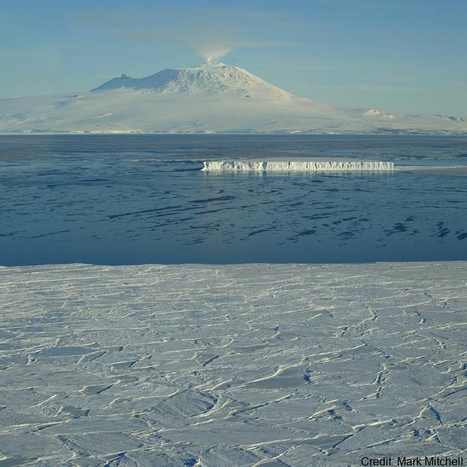
Sea ice temperature (°C) measured across multiple depths at (LATITUDE: -77.792300, LONGITUDE: 166.514900). Related Publication: Richter ME, Leonard GH, Smith IJ, Langhorne PJ, Mahoney AR, Parry M. Accuracy and precision when deriving sea-ice thickness from thermistor strings: a comparison of methods. Journal of Glaciology. 2023;69(276):879-898. doi:10.1017/jog.2022.108 GET DATA: https://doi.org/10.1594/PANGAEA.880164
-
This layer contains the DSM for LiDAR data from Golden Bay - Aorere Extension, Lee Dam, St Arnaud and Farewell Spit captured in 2017. - The DEM is available as layer [Tasman - Golden Bay LiDAR 1m DEM (2017)](http://data.linz.govt.nz/layer/95503-tasman-golden-bay-lidar-1m-dem-2017/). - The index tiles are available as layer [Tasman - Golden Bay LiDAR Index Tiles (2017)](http://data.linz.govt.nz/layer/95627-goldenbaytilelayout/). - The LAS point cloud and vendor project reports are available from [OpenTopography](https://portal.opentopography.org/datasets?loc=New%20Zealand). Lidar was captured for Tasman District Council by AAM New Zealand in November and December 2017. The datasets were generated by AAM New Zealand and their subcontractors. Data management and distribution is by Land Information New Zealand. Data comprises: - DEM: tif or asc tiles in NZTM2000 projection, tiled into a 1:1,000 tile layout - DSM: tif or asc tiles in NZTM2000 projection, tiled into a 1:1,000 tile layout - Point cloud: las tiles in NZTM2000 projection, Farewell Spit tiled into a 1:1,000 tile layout, the rest of the data tiled into a 1:2,000 tile layout Pulse density specification is 2 pulses/square metre. Vertical accuracy specification is +/- 0.12m (95%). Horizontal accuracy specification is +/- 1.00m (95%). Vertical datum is NZVD2016.
-
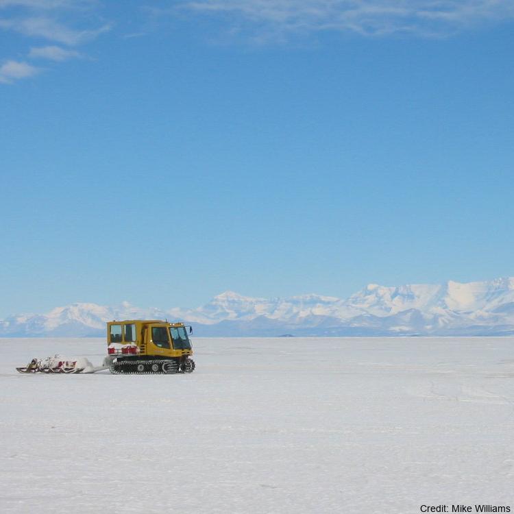
Sea ice temperature (°C) measured across multiple depths from 20 cm to 207.5 cm at (latitude: -77.775800, longitude: 166.312800): Related Publication: Richter ME, Leonard GH, Smith IJ, Langhorne PJ, Mahoney AR, Parry M. Accuracy and precision when deriving sea-ice thickness from thermistor strings: a comparison of methods. Journal of Glaciology. 2023;69(276):879-898. doi:10.1017/jog.2022.108
-
This layer contains the DEM for LiDAR data from Golden Bay - Aorere Extension, Lee Dam, St Arnaud and Farewell Spit captured in 2017. - The DSM is available as layer [Tasman - Golden Bay LiDAR 1m DSM (2017)](http://data.linz.govt.nz/layer/95512-tasman-golden-bay-lidar-1m-dsm-2017/). - The index tiles are available as layer [Tasman - Golden Bay LiDAR Index Tiles (2017)](http://data.linz.govt.nz/layer/95627-goldenbaytilelayout/). - The LAS point cloud and vendor project reports are available from [OpenTopography](https://portal.opentopography.org/datasets?loc=New%20Zealand). Lidar was captured for Tasman District Council by AAM New Zealand in November and December 2017. The datasets were generated by AAM New Zealand and their subcontractors. Data management and distribution is by Land Information New Zealand. Data comprises: - DEM: tif or asc tiles in NZTM2000 projection, tiled into a 1:1,000 tile layout - DSM: tif or asc tiles in NZTM2000 projection, tiled into a 1:1,000 tile layout - Point cloud: las tiles in NZTM2000 projection, Farewell Spit tiled into a 1:1,000 tile layout, the rest of the data tiled into a 1:2,000 tile layout Pulse density specification is 2 pulses/square metre. Vertical accuracy specification is +/- 0.12m (95%). Horizontal accuracy specification is +/- 1.00m (95%). Vertical datum is NZVD2016.
-
**Please read:** This table is part of the comprehensive [Full Landonline Dataset](https://data.linz.govt.nz/group/full-landonline-dataset/) and is designed for use only by data professionals who require the complex version of our property ownership and boundary data for advanced uses. ************************* This table contains detailed information about changes to Landonline coordinates, and how accurate they are. This can be combined with data in other tables to assess the likely reliability of coordinates by providing details of the adjustment date, connections to geodetic control and amount the coordinates changed by at each adjustment. Please refer to the [LDS Full Landonline Data Dictionary and Models](https://data.linz.govt.nz/document/11095) for detailed metadata about this table.
-
This layer contains the Index Tiles for LiDAR data from Golden Bay - Aorere Extension, Lee Dam, St Arnaud and Farewell Spit captured in 2017. - The DEM is available as layer [Tasman - Golden Bay LiDAR 1m DEM (2017)](http://data.linz.govt.nz/layer/95503-tasman-golden-bay-lidar-1m-dem-2017/). - The DSM is available as layer [Tasman - Golden Bay LiDAR 1m DSM (2017)](http://data.linz.govt.nz/layer/95512-tasman-golden-bay-lidar-1m-dsm-2017/). - The LAS point cloud and vendor project reports are available from [OpenTopography](https://portal.opentopography.org/datasets?loc=New%20Zealand). Lidar was captured for Tasman District Council by AAM New Zealand in November and December 2017. The datasets were generated by AAM New Zealand and their subcontractors. Data management and distribution is by Land Information New Zealand. Data comprises: - DEM: tif or asc tiles in NZTM2000 projection, tiled into a 1:1,000 tile layout - DSM: tif or asc tiles in NZTM2000 projection, tiled into a 1:1,000 tile layout - Point cloud: las tiles in NZTM2000 projection, Farewell Spit tiled into a 1:1,000 tile layout, the rest of the data tiled into a 1:2,000 tile layout Pulse density specification is 2 pulses/square metre. Vertical accuracy specification is +/- 0.12m (95%). Horizontal accuracy specification is +/- 1.00m (95%). Vertical datum is NZVD2016.
-
**Orthophotography for the Tasman region taken in the flying season (summer period) of 2016-2017. Covering the area centred primarily around Murchison** Imagery was captured for the ‘Tasman District Council’ by AAM NZ Limited, 6 Ossian St, NAPIER, New Zealand. Data has subsequently been provided to LINZ and this comprises: • 338 x ortho-rectified RGB GeoTIFF images in NZTM projection, tiled into the LINZ Standard 1:5,000 tile layout •Tile layout in NZTM projection containing relevant information. The supplied imagery is in terms of New Zealand Transverse Mercator (NZTM) map projection. The products are tiled into NZTopo50 1:5,000 tiles. Please refer to the supplied tile layout shape file for specific details, naming conventions, etc. Imagery supplied as 30cm pixel resolution (0.3m GSD), 3-band (RGB) uncompressed GeoTIFF. The final spatial accuracy is +/-1.2m @ 90% confidence level. Index tiles for this dataset are available as layer [Tasman 0.3m Rural Aerial Photos Index Tiles (2016-17)](http://data.linz.govt.nz/layer/88091)
-
Index Tiles ONLY, for actual orthophotos see layer [Tasman 0.1m Urban Aerial Photos (2017)](http://data.linz.govt.nz/layer/104167) Orthophotography within the Tasman region taken in the flying season (summer period) of 2017-2018. Coverage encompassed the urban areas within the Tasman District Council area. Imagery was captured for the ‘Tasman District Council’ by AAM NZ Limited, 6 Ossian St, NAPIER, New Zealand. Data comprises: • 300 x ortho-rectified RGB GeoTIFF images in NZTM projection, tiled into the LINZ Standard 1:1,000 tile layout •Tile layout in NZTM projection containing relevant information. The supplied imagery is in terms of New Zealand Transverse Mercator (NZTM) map projection. Please refer to the supplied tile layout shape file for specific details, naming conventions, etc. Imagery supplied as 10cm pixel resolution (0.2m GSD), 3-band (RGB) uncompressed GeoTIFF. The final spatial accuracy is ±0.2m @ 90% confidence level.
-
Index Tiles ONLY, for actual orthophotos see layer [Hamilton 0.1m Urban Aerial Photos (2016-17)](http://data.linz.govt.nz/layer/88132) Orthophotography over Hamilton City taken in the flying season (summer period) 2016 -17. Imagery was captured for the ‘Hamilton City Council’ by Aerial Surveys Ltd, Unit A1, 8 Saturn Place, Albany,0632, New Zealand. Data comprises: •492 ortho-rectified RGB GeoTIFF images in NZTM projection, tiled into the LINZ Standard 1:1,000 tile layout •Tile layout in NZTM projection containing relevant information. The supplied imagery is in terms of New Zealand Transverse Mercator (NZTM) map projection. The products are tiled into NZTopo50 1:1,000 tiles. Please refer to the supplied tile layout shape file for specific details, naming conventions, etc. Imagery supplied as 10cm pixel resolution (0.1m GSD), 3-band (RGB) uncompressed GeoTIFF. The final spatial accuracy is ±0.2 m @ 95% confidence level in clear open spaces.