 GeoData.NZ

Type of resources
Available actions
Topics
Keywords
Contact for the resource
Provided by
Years
Update frequencies
status
-
This metadata record represents environmental DNA sequence data and metadata barcode file. Seawater and sponge eDNA metabarcoding sampling was conducted at seven coastal locations (Cape Barne, Cape Evans, Cziko Seamount, Granite Harbor Middle, Granite Harbor South, and Turtle Rock) in the Ross Sea to assess spatial eukaryote biodiversity patterns and investigate eDNA signal differences between both substrates. Five replicate 500 mL water samples were collected at each of seven locations within 2 m of the ocean floor using a Niskin bottle. At the same time, five sponge specimens were collected by ROV at a depth range of 18–30 m from three out of the seven locations, thereby enabling sponge and near-bottom water eDNA signal comparison. Further details and laboratory procedures can be found in https://doi.org/10.1002/edn3.500 GET DATA: https://figshare.com/projects/Unveiling_the_Hidden_Diversity_of_Marine_Eukaryotes_in_the_Ross_Sea_A_Comparative_Analysis_of_Seawater_and_Sponge_eDNA_Surveys/186127
-

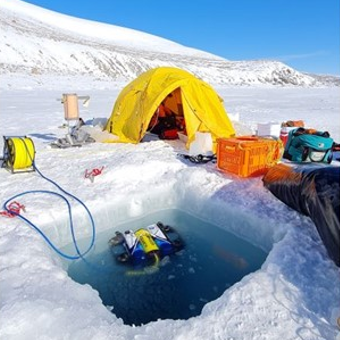
Contained in this folder are the raw and processed data files for data collected with the underwater robot Icefin in the ocean cavity beneath Ross Ice Shelf, near the grounding line of Kamb Ice Stream. Most of these data are located within a basal crevasse. They were collected in December 2019 as part of the Aotearoa New Zealand Antarctic Science Platform and Victoria University of Wellington Hot Water Drilling initiative, and the NASA RISEUP grant (NNX16AL07G, PI B. E. Schmidt). The code that converted raw data files to processed can be found at https://zenodo.org/record/8338529. Direct questions to Peter Washam at pwasham@cornell.edu. RELATED PUBLICATION: https://doi.org/10.1126/sciadv.adi7638 GET DATA: https://doi.org/10.15784/601733
-
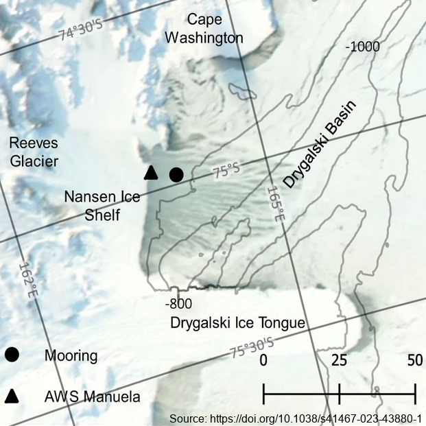
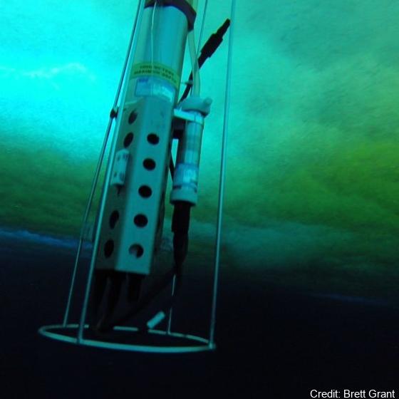
The mooring was deployed from February 2017 through February 2018 at 74.97° S, 163.96° E, approximately 7km east of the Nansen Ice Shelf in a region of TNB. The purpose of this study was to utilize data from a uniquely positioned and densely instrumented mooring to calculate HSSW production rates in TNB from continuous, in-situ observations. Moored instrumentation consisted of 7 SeaBird Electronics conductivity and temperature (SBE37-SM/SMP MicroCAT) sensors at depths of 47, 95, 119, 144, 168, 219, and 360 m and an upward-facing 600 kHz Nortek Acoustic Wave and Current (AWAC) profiler at 37 m depth, collecting both current velocity profiles in the upper ~35 m of the water column as well as Acoustic Surface Tracking (AST) measurements. Temperature and salinity measurements were validated against a shipboard conductivity-temperature-depth (CTD) cast performed upon deployment of the mooring. Temperature and salinity at 47 m and 95 m were additionally validated against a CTD cast performed upon recovery of the mooring. Full details of methods can be found in https://doi.org/10.1038/s41467-023-43880-1 GET DATA: ukm2103@columbia.edu
-
These data are described in detail by 'Melting and refreezing in an ice shelf basal channel at the grounding line of the Kamb Ice Stream. ApRES observations were made in December 2019 and repeated in December 2020 at the same locations. Data collection and processing followed the method described in Stewart et al. (2019). ApRES dataset.zip' contains raw ApRES data and processed results from a spatial survey of basal mass balance - detailed in Sections 2.2.4 and 3.2.2 of https://doi.org/10.1029/2021JF006532. GET DATA: https://doi.org/10.5281/zenodo.5574647
-
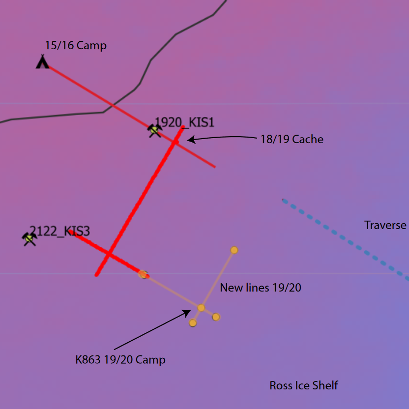
This work was primarily funded by the NASA-funded RISE-UP: Ross Ice Shelf & Europa Underwater Probe (PI Britney E. Schmidt) project. Field work at the KIS-1 site during the 2019-2020 season was completed through international collaboration between NASA, NSF/USAP, and Antarctica New Zealand, funded by the Aotearoa New Zealand Antarctic Science Platform (ANTA1801) Antarctic Ice Dynamics Project (ASP02101), and the NZARI-funded Aotearoa New Zealand Ross Ice Shelf Programme, “Vulnerability of the Ross Ice Shelf in a Warming World” (grant no. 2014-11). The data contained in this directory are merged and calibrated data files from three missions conducted with ROV Icefin through a borehole drilled through Ross Ice Shelf at KIS1 (-82.78410, -155.26267), near the Kamb Ice Stream grounding zone. Missions were conducted in 2019 on December 16th, 18th, and 21st (UTC). For questions or assistance working with the data please contact Britney Schmidt (britneys@cornell.edu) and Justin Lawrence (jdl287@cornell.edu). Related Publication: https://doi.org/10.1038/s41561-023-01129-y GET DATA: https://doi.org/10.15784/601625
-
Data from a measurement campaign examining the oceanic connection between an ice shelf cavity and sea ice. Here we present data from the ocean boundary-layer in an Ice Shelf Water outflow region from the Ross/McMurdo Ice Shelves. From a fast ice field camp during the Spring of 2015, we captured the kinematics of free-floating relatively large (in some cases 10s of mm in scale) ice crystals that were advecting and then settling upwards in a depositional layer on the sea ice underside (SIPL, sub-ice platelet layer). Simultaneously, we measured the background oceanic temperature, salinity, currents and turbulence structure. At the camp location the total water depth was 536 m, with the uppermost 50 m of the water column being in-situ super-cooled. Tidal flow speeds had an amplitude of around 0.1 m s-1 with dissipation rates in the under-ice boundary layer measured to be up to e=10-6 W kg-1. Acoustic sampling (200 kHz) identified backscatter from large, individually identifiable suspended crystals associated with crystal sizes larger than normally described as frazil. Crystal sizes in the SIPL were also measured. RELATED PUBLICATION: https://doi.org/10.3389/fmars.2023.1103740 GET DATA: https://doi.org/10.17882/90432
-
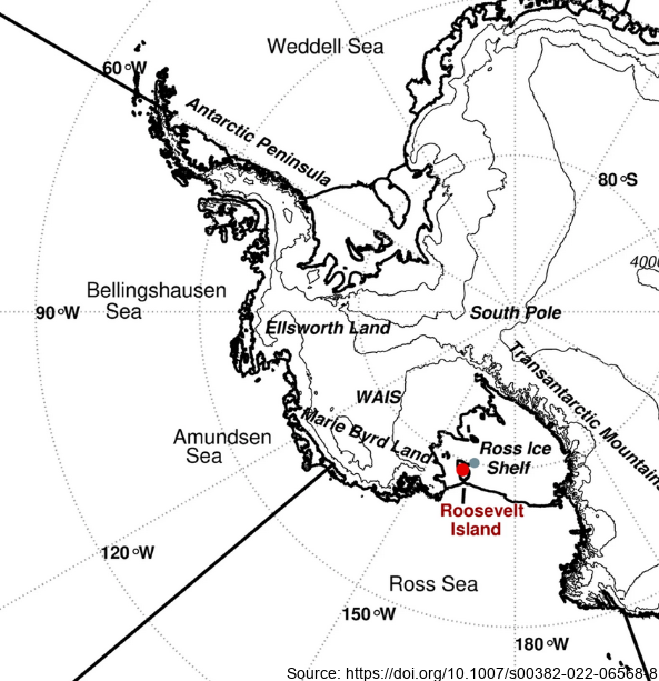
Here we examine the water stable-isotope data from the Roosevelt Island Climate Evolution (RICE) ice core. In this study, we use empirical orthogonal function (EOF) analysis to investigate the relationship between RICE ice-core oxygen-18 isotopes (δ18O) and Southern Hemisphere atmospheric circulation during the extended austral winter (April–November). - Deep Location: 79.364°S, 161.706°W, elevation 550 m a.s.l. - 12/13B Location: 79.362°S, 161.698°W, elevation 550 m a.s.l. - Core depth 763 m. Depth interval provided here: 1.29 to 38.56 m - txt data file, NaN = no data Further details are available at https://doi.org/10.1007/s00382-022-06568-8 GET DATA: https://github.com/demanuelsson/ClimDyn_2022_Matlab/tree/main/data
-
Plot data Mc Nemar: To enable comparisons with the 1961 and 2004 survey results, the Lambert Conformal Conic projection from the 2004 survey was used to precisely georeference and trim the RGB image across a 1-m2 grid, generating a total of 3,458 1-m2 grid cells. For each grid cell moss, lichen, or algae/cyanobacteria cover was extracted as one of the four cover classes: Heavy (>40%), Patchy (10–40%), Scattered (less than 10%), and None (0%) for the survey years 1962, 2004 and 2018. Ground truthing: To test the overall accuracy of cover classifications and ensure consistency with 2004 survey methodologies, a ground-truthing approach was performed. Photographs were taken of individual cells along eight transects, running west to east across the plot at 0.5, 1.5, 15.5, 16.5, 28.5, 29.5, 116.5 and 117.5 m distance from the NW corner. Each grid cell could be identified individually with an x/y coordinate in the centre and was surrounded by a rectangular frame parallel to the outer edge of the plot. A total of 174 photographs were taken and archived with Antarctica New Zealand. For each photographed grid cell, the presence of each functional group of vegetation and their cover class was assessed visually. Orthomosaic image: Aerial images were obtained using a DJI Matrice 600 Pro hex-rotor remotely piloted aircraft system equipped with a Canon EOS 5Ds camera (image size: 8688×5792 pixels, focal length: 50 mm, pixel size: 4.14 μm) on November 28, 2018. The flight altitude was 30 m above ground level, and a total of 10 ground-control points were included to provide accurate geo-referencing. An orthomosaic photo and accompanying DEM was generated with the acquired aerial images using Agisoft PhotoScan (now known as Metashape by Agisoft LLC, https://www.agisoft.com/) RELATED PUBLICATION: https://doi.org/10.1029/2022EF002823 GET DATA: https://doi.org/10.7488/ds/3417
-
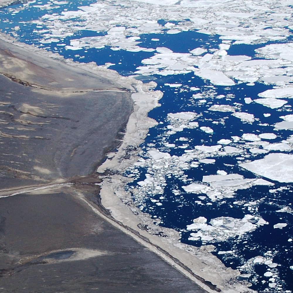
Aerial reconnaissance and photography are used in the Ross Sea sector of Antarctica to determine the breeding locations of Adélie penguins and to count the numbers of nests occupied during the early incubation period. From 1981 to present (two-year embargo), all islands and sea coasts between 158°E and 175°E have been searched, and 11 previously unreported breeding colonies discovered. The aim is to census Adélie (Pygoscelis adeliae) populations to provide basic data against which future population levels can be compared in order to monitor environmental change of the Antarctic Ocean ecosystem, both natural and man-induced. GET DATA: https://datastore.landcareresearch.co.nz/en_AU/dataset/adelie-penguin-census-data
-
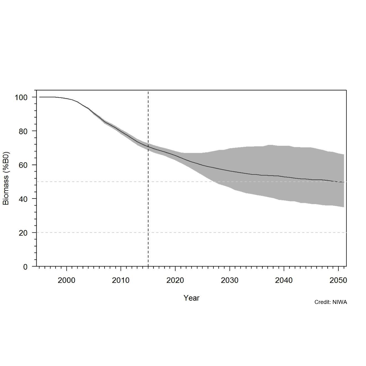
Knowledge of recruitment dynamics, and in particular trends in recruitment and recruitment variability, are key inputs for integrated assessments of fish stocks. A quantitative longline survey monitoring the recruitment of Antarctic toothfish (Dissotichus mawsoni) in the southern Ross Sea was started in 2012. The survey was expanded in 2016 to monitor trends and biological characteristics in two areas of importance to predators, Terra Nova Bay and McMurdo Sound, and to collect data that would contribute to the research and monitoring plan for the Ross Sea region Marine Protected Area. In most years, the survey was completed as planned, while in three years several factors have constrained the survey from sampling all stations and in the latest two seasons pandemic travel restrictions have necessitated an alternative delivery approach. Between 2012 and 2022, 2 056 tagged Antarctic toothfish have been released on the survey and 21 toothfish have been recaptured. Fifteen pop-up satellite archival tags (PSATs) were deployed on D. mawsoni in 2019 and fifteen skates were tagged in 2020 and 2021. Many tagged toothfish released from the RSSS move from the shelf to the slope. Trends in abundance indices and size and age composition consistently show the progression of strong year classes entering and leaving the survey area and have indicated that recruitment is likely more variable than previously thought. Data from the RSSS have been used to indicate year class strength in Antarctic toothfish stock assessments since 2015. The twelve surveys to date have resulted in a substantive increase in the knowledge and understanding of the distribution and relative abundance of a range of demersal fish species and invertebrate taxa caught on the longlines. Other data routinely collected on the surveys were plankton, temperature, salinity, air quality, cetacean and other marine mammal observations, and photo, video, and echosounder data. The RSSS has provided synergies with other research programmes also addressing CCAMLR objectives, particularly those focused on research and monitoring within the RSrMPA. GET DATA: https://www.ccamlr.org/en/publications/statistical-bulletin