 GeoData.NZ
TEMPERATURE PROBES
Type of resources
Available actions
Topics
Keywords
Contact for the resource
Provided by
Years
status
-
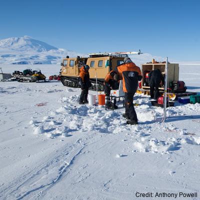
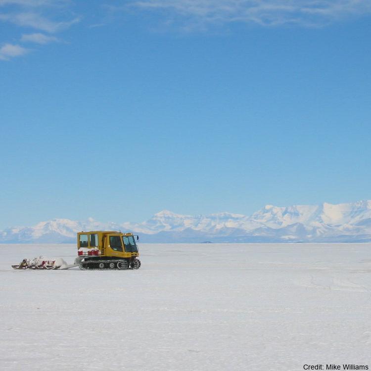
Sea ice temperature (°C) measured across 11 depths (57 cm, 78.5 cm, 84.5 cm, 87.5 cm, 96.5 cm, 105.5 cm, 108.5 cm, 114.5 cm, 117.5 cm, 120.5 cm, 129.5 cm) at (LATITUDE: -77.781700, LONGITUDE: 166.315300): Related Publication: Richter ME, Leonard GH, Smith IJ, Langhorne PJ, Mahoney AR, Parry M. Accuracy and precision when deriving sea-ice thickness from thermistor strings: a comparison of methods. Journal of Glaciology. 2023;69(276):879-898. doi:10.1017/jog.2022.108
-
Sea ice temperature (°C) measured across multiple depths from 20 cm to 207.5 cm at (latitude: -77.775800, longitude: 166.312800): Related Publication: Richter ME, Leonard GH, Smith IJ, Langhorne PJ, Mahoney AR, Parry M. Accuracy and precision when deriving sea-ice thickness from thermistor strings: a comparison of methods. Journal of Glaciology. 2023;69(276):879-898. doi:10.1017/jog.2022.108
-
Sea ice temperature (°C) measured across multiple depths at (LATITUDE: -77.794900, LONGITUDE: 166.334700). Related Publication: Richter ME, Leonard GH, Smith IJ, Langhorne PJ, Mahoney AR, Parry M. Accuracy and precision when deriving sea-ice thickness from thermistor strings: a comparison of methods. Journal of Glaciology. 2023;69(276):879-898. doi:10.1017/jog.2022.108 GET DATA: https://doi.org/10.1594/PANGAEA.880165
-
Sea ice temperature (°C) measured across multiple depths at (LATITUDE: -77.792300, LONGITUDE: 166.514900). Related Publication: Richter ME, Leonard GH, Smith IJ, Langhorne PJ, Mahoney AR, Parry M. Accuracy and precision when deriving sea-ice thickness from thermistor strings: a comparison of methods. Journal of Glaciology. 2023;69(276):879-898. doi:10.1017/jog.2022.108 GET DATA: https://doi.org/10.1594/PANGAEA.880164
-
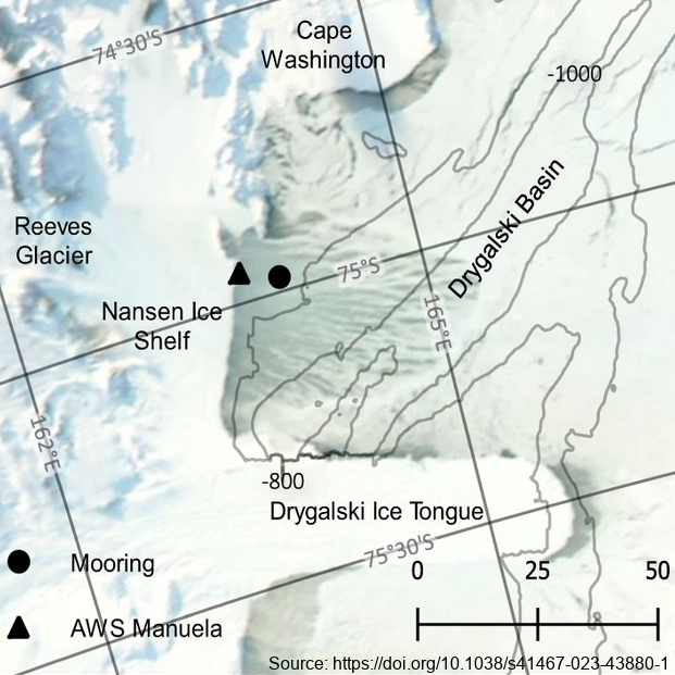
The mooring was deployed from February 2017 through February 2018 at 74.97° S, 163.96° E, approximately 7km east of the Nansen Ice Shelf in a region of TNB. The purpose of this study was to utilize data from a uniquely positioned and densely instrumented mooring to calculate HSSW production rates in TNB from continuous, in-situ observations. Moored instrumentation consisted of 7 SeaBird Electronics conductivity and temperature (SBE37-SM/SMP MicroCAT) sensors at depths of 47, 95, 119, 144, 168, 219, and 360 m and an upward-facing 600 kHz Nortek Acoustic Wave and Current (AWAC) profiler at 37 m depth, collecting both current velocity profiles in the upper ~35 m of the water column as well as Acoustic Surface Tracking (AST) measurements. Temperature and salinity measurements were validated against a shipboard conductivity-temperature-depth (CTD) cast performed upon deployment of the mooring. Temperature and salinity at 47 m and 95 m were additionally validated against a CTD cast performed upon recovery of the mooring. Full details of methods can be found in https://doi.org/10.1038/s41467-023-43880-1 GET DATA: ukm2103@columbia.edu
-

In collaboration between Korea Polar Research Institute LDEO and NIWA, an oceanographic mooring was deployed close to the bottom depth in the Drygalski Basin (lat:-75.010487, lon:165.555680) on 6 March 2018 as a part of the ANA08C research cruise, and it was recovered on 5 January 2019. To monitor physical properties (Temperature, Salinity, Current) of deep water in the Drygalski Basin. GET DATA: https://kpdc.kopri.re.kr/search/992862c1-84d0-46aa-97dd-e2dcfb12357e
-

In collaboration between Korea Polar Research Institute and NIWA, an oceanographic mooring was deployed close to the bottom depth near the Drygalski Ice Tongue (lat:-75.275700, lon:164.067300) on 9 March 2018 as a part of the ANA08C research cruise, and it was recovered on 3 January 2019. To monitor physical properties (Temperature, Salinity, Current) of deep water near the Drygalski Ice Tongue. GET DATA: https://kpdc.kopri.re.kr/search/9826749c-376a-4751-8812-702cec76c4c0
-

In collaboration between the Korea Polar Research Institute and NIWA, an oceanographic mooring was deployed close to the bottom depth near the Drygalski Ice Tongue (lat:-75.275700, lon:164.067300) on 5 February 2017 as a part of the ANA07C research cruise, and it was recovered on 5 March 2018. To monitor physical properties (Temperature, Salinity, Current) of deep water near the Drygalski Ice Tongue. GET DATA: https://kpdc.kopri.re.kr/search/023da26f-ba92-43ee-ab54-8ec5fbcf133b
-

In collaboration between Korea Polar Research Institute and NIWA, an oceanographic mooring was deployed to the south of the Drygalski Ice Tongue (lat:-75.488417, lon:163.174350) on 12 February 2017 as a part of the ANA07C research cruise, and it was recovered on 7 March 2018. To monitor physical properties (Temperature, Salinity, Current) of ocean water in the south of the Drygalski Ice Tongue. GET DATA: https://kpdc.kopri.re.kr/search/9245184f-b187-4c1e-ad6f-32ed1f9493c8
-

In collaboration between the Korea Polar Research Institute and NIWA, an oceanographic mooring was deployed close to the bottom depth near the Drygalski Ice Tongue (lat:-75.275700, lon:164.067300) on March 2020, and it was recovered on March 2022 (ANA12D research cruise) To monitor physical properties (Temperature, Salinity, Current) of deep water near the Drygalski Ice Tongue. GET DATA: https://kpdc.kopri.re.kr/search/17597739-8a74-45c9-8816-8adbcd11209f