 GeoData.NZ
ROVS
Type of resources
Topics
Keywords
Contact for the resource
Provided by
Years
Update frequencies
status
-
This metadata record represents environmental DNA sequence data and metadata barcode file. Seawater and sponge eDNA metabarcoding sampling was conducted at seven coastal locations (Cape Barne, Cape Evans, Cziko Seamount, Granite Harbor Middle, Granite Harbor South, and Turtle Rock) in the Ross Sea to assess spatial eukaryote biodiversity patterns and investigate eDNA signal differences between both substrates. Five replicate 500 mL water samples were collected at each of seven locations within 2 m of the ocean floor using a Niskin bottle. At the same time, five sponge specimens were collected by ROV at a depth range of 18–30 m from three out of the seven locations, thereby enabling sponge and near-bottom water eDNA signal comparison. Further details and laboratory procedures can be found in https://doi.org/10.1002/edn3.500 GET DATA: https://figshare.com/projects/Unveiling_the_Hidden_Diversity_of_Marine_Eukaryotes_in_the_Ross_Sea_A_Comparative_Analysis_of_Seawater_and_Sponge_eDNA_Surveys/186127
-
Data includes estimates of abundance of seaweed taxa on the seafloor across the Northern Victoria Land coast, Ross Sea, Antarctica. This includes: - Metadata of video transects - Seaweed density across transects - Modelled outputs of light attenuation across sites. Descriptions: - "Antarctic_Seaweed_Metadata_TAN2101_TAN2302_Dryad.xlsx" - Metadata of video transects, date and time, locations, gear, depth, distance covered. - "Antarctic_Seaweeds_TAN2101_TAN2302.csv" - Density of seaweed functional groups across video transects - "Light_transects_TAN2021_TAN2302.csv" - Outputs of light modelling for seafloor regions of the Ross Sea - "Antarctic_Seaweed_RScript_Tait_etal_2024.txt" - R sripts used to plot, analyse and model the above datasets Further details are provided at: Tait, L.W., Chin, C., Nelson, W. et al. Deep-living and diverse Antarctic seaweeds as potentially important contributors to global carbon fixation. Commun Earth Environ 5, 205 (2024). https://doi.org/10.1038/s43247-024-01362-2 GET DATA: https://doi.org/10.5061/dryad.w6m905qwz
-
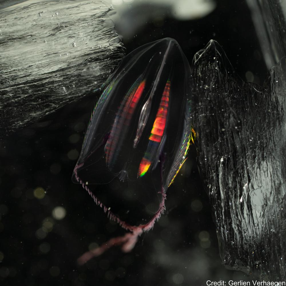
This Zenodo dataset contain the Common Objects in Context (COCO) files linked to the following publication: Each COCO zip folder contains an "annotations" folder including a json file and an "images" folder containing the annotated images. Verhaegen, G, Cimoli, E, & Lindsay, D (2021). Life beneath the ice: jellyfish and ctenophores from the Ross Sea, Antarctica, with an image-based training set for machine learning. Biodiversity Data Journal. https://doi.org/10.3897/BDJ.9.e69374 GET DATA: https://doi.org/10.5281/zenodo.5118012 GET DATA: http://ipt.pensoft.net/resource?r=life_beneath_the_ice-jellyfish_and_ctenophores_from_the_ross_sea_antarctica&v=1.3
-
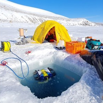
This work was primarily funded by the NASA-funded RISE-UP: Ross Ice Shelf & Europa Underwater Probe (PI Britney E. Schmidt) project. Field work at the KIS-1 site during the 2019-2020 season was completed through international collaboration between NASA, NSF/USAP, and Antarctica New Zealand, funded by the Aotearoa New Zealand Antarctic Science Platform (ANTA1801) Antarctic Ice Dynamics Project (ASP02101), and the NZARI-funded Aotearoa New Zealand Ross Ice Shelf Programme, “Vulnerability of the Ross Ice Shelf in a Warming World” (grant no. 2014-11). The data contained in this directory are merged and calibrated data files from three missions conducted with ROV Icefin through a borehole drilled through Ross Ice Shelf at KIS1 (-82.78410, -155.26267), near the Kamb Ice Stream grounding zone. Missions were conducted in 2019 on December 16th, 18th, and 21st (UTC). For questions or assistance working with the data please contact Britney Schmidt (britneys@cornell.edu) and Justin Lawrence (jdl287@cornell.edu). Related Publication: https://doi.org/10.1038/s41561-023-01129-y GET DATA: https://doi.org/10.15784/601625
-

Contained in this folder are the raw and processed data files for data collected with the underwater robot Icefin in the ocean cavity beneath Ross Ice Shelf, near the grounding line of Kamb Ice Stream. Most of these data are located within a basal crevasse. They were collected in December 2019 as part of the Aotearoa New Zealand Antarctic Science Platform and Victoria University of Wellington Hot Water Drilling initiative, and the NASA RISEUP grant (NNX16AL07G, PI B. E. Schmidt). The code that converted raw data files to processed can be found at https://zenodo.org/record/8338529. Direct questions to Peter Washam at pwasham@cornell.edu. RELATED PUBLICATION: https://doi.org/10.1126/sciadv.adi7638 GET DATA: https://doi.org/10.15784/601733