 GeoData.NZ
GNSS
Type of resources
Topics
Keywords
Contact for the resource
Provided by
Years
Formats
Update frequencies
status
-

This is GNSS data of four stations covering the grounding zone of Priestley Glacier Antarctica. Tidal modulation of ice streams and their adjacent ice shelves is a real-world experiment to understand ice-dynamic processes. We observe the dynamics of Priestley Glacier, Antarctica, using Terrestrial Radar Interferometry (TRI) and GNSS. Ocean tides are predominantly diurnal but horizontal GNSS displacements oscillate also semi-diurnally. The oscillations are strongest in the ice shelf and tidal signatures decay near-linearly in the TRI data over >10 km upstream of the grounding line. Tidal flexing is observed >6 km upstream of the grounding line including cm-scale uplift. Tidal grounding line migration is small and <40 % of the ice thickness. The frequency doubling of horizontal displacements relative to the ocean tides is consistent with variable ice-shelf buttressing demonstrated with a visco-elastic Maxwell model. Taken together, this supports previously hypothesized flexural ice softening in the grounding-zone through tides and offers new observational constraints for the role of ice rheology in ice-shelf buttressing. Related Publication: Drews, R., Wild, C. T., Marsh, O. J., Rack, W., Ehlers, T. A., Neckel, N., & Helm, V. (2021). Grounding-zone flow variability of Priestley Glacier, Antarctica, in a diurnal tidal regime. Geophysical Research Letters, 48, e2021GL093853. https://doi.org/10.1029/2021GL093853 GET DATA: https://doi.pangaea.de/10.1594/PANGAEA.936090
-
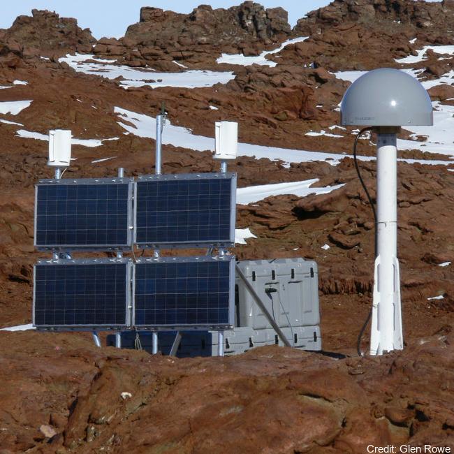
The network collects Global Navigation Satellite System (GNSS) data for the purposes of monitoring the New Zealand Geodetic Datum 2000 (NZGD2000), updating the national deformation model, and maintaining New Zealand’s relationship to the International Terrestrial Reference Frame (ITRF). Antarctic GNSS data form part of the New Zealand campaign GNSS (Global Navigation Satellite System) surveys. Data have been collected by periodic campaign style GNSS surveys. High accuracy continuous Global Positioning System tracking stations in Antarctica: - Scott Base (SCTB - LINZ Geodetic Code) and was operational as of 29 October 2004. - Butcher Ridge (BURI- LINZ Geodetic Code) on 7 December 2007. - Minna Bluff (MIN0- LINZ Geodetic Code) on 31 January 2007. - Cape Roberts (ROB4- LINZ Geodetic Code) on 29 November 2005. Data are available in Receiver Independent Exchange Format (RINEX) files at 30 or 15 seconds sampling rate. GET DATA: https://www.geodesy.linz.govt.nz/positionz/?page=text GET DATA: https://www.linz.govt.nz/products-services/geodetic/positionz/positionz-real-time-service
-

These data were aquired with a Terrestrial Radar Interferometer overlooking the grounding zone of Priestley Glacier, Antarctica. The time series contains differential interferograms with a 12h temporal baseline covering an approximately 8 day period in November 2018. Tidal modulation of ice streams and their adjacent ice shelves is a real-world experiment to understand ice-dynamic processes. We observe the dynamics of Priestley Glacier, Antarctica, using Terrestrial Radar Interferometry (TRI) and GNSS. Ocean tides are predominantly diurnal but horizontal GNSS displacements oscillate also semi-diurnally. The oscillations are strongest in the ice shelf and tidal signatures decay near-linearly in the TRI data over >10 km upstream of the grounding line. Tidal flexing is observed >6 km upstream of the grounding line including cm-scale uplift. Tidal grounding line migration is small and <40 % of the ice thickness. The frequency doubling of horizontal displacements relative to the ocean tides is consistent with variable ice-shelf buttressing demonstrated with a visco-elastic Maxwell model. Taken together, this supports previously hypothesized flexural ice softening in the grounding-zone through tides and offers new observational constraints for the role of ice rheology in ice-shelf buttressing. Time series of line-of-sight flowfields averaged over approximately three hours. Data were taken with a Terrestrial Radar Interferometer in November 2018 at the grounding zone of Priestley Glacier, Antarctica – The Zip Archive contains 288 Geotiff in South polar stereographic projection – Each raster has 4027 x 4746 entries – The file name details the approximately 3h time inverval of aquisition with Stack_YYYYMMDD_HHMMSS_YYYYMMDD_HHMMSS marking the beginning and end of the time interval, respectively. – The line of sight velocities are given in meters per year Related Publication: Drews, R., Wild, C. T., Marsh, O. J., Rack, W., Ehlers, T. A., Neckel, N., & Helm, V. (2021). Grounding-zone flow variability of Priestley Glacier, Antarctica, in a diurnal tidal regime. Geophysical Research Letters, 48, e2021GL093853. https://doi.org/10.1029/2021GL093853 GET DATA: https://doi.org/10.1594/PANGAEA.935702
-
These data were aquired with a Terrestrial Radar Interferometer overlooking the grounding zone of Priestley Glacier, Antarctica. The time series contains differential interferograms with a 12h temporal baseline covering an approximately 8 day period in November 2018. Tidal modulation of ice streams and their adjacent ice shelves is a real-world experiment to understand ice-dynamic processes. We observe the dynamics of Priestley Glacier, Antarctica, using Terrestrial Radar Interferometry (TRI) and GNSS. Ocean tides are predominantly diurnal but horizontal GNSS displacements oscillate also semi-diurnally. The oscillations are strongest in the ice shelf and tidal signatures decay near-linearly in the TRI data over >10 km upstream of the grounding line. Tidal flexing is observed >6 km upstream of the grounding line including cm-scale uplift. Tidal grounding line migration is small and <40 % of the ice thickness. The frequency doubling of horizontal displacements relative to the ocean tides is consistent with variable ice-shelf buttressing demonstrated with a visco-elastic Maxwell model. Taken together, this supports previously hypothesized flexural ice softening in the grounding-zone through tides and offers new observational constraints for the role of ice rheology in ice-shelf buttressing. Related Publication: Drews, R., Wild, C. T., Marsh, O. J., Rack, W., Ehlers, T. A., Neckel, N., & Helm, V. (2021). Grounding-zone flow variability of Priestley Glacier, Antarctica, in a diurnal tidal regime. Geophysical Research Letters, 48, e2021GL093853. https://doi.org/10.1029/2021GL093853 GET DATA: https://doi.org/10.1594/PANGAEA.935707
-

"GeoNet Aotearoa New Zealand Stations Metadata Repository" is a relational database providing information about current and past instruments forming the GeoNet's continuously recording sensor network. The database contains information around networks, station geographical location, installed scientific equipment and their deployment history, calibration files and essential information about the physical environment in which those instruments are located. Stations metadata are provided in tabular format and information about different type of networks might be integrated and combined in the same file or group of files. The database is maintained and curated by GNS Science through the GeoNet programme. It covers a time range that precedes the programme and contains metadata of recording stations that were operating in the early 20th century. The database structure is not domain specific, and it is published in a version controlled system. The "GeoNet Aotearoa New Zealand stations metadata repository" is archived and publicly available and commonly referred to as "delta". This dataset is funded by the New Zealand Government through its agencies: https://www.geonet.org.nz/sponsors DOI : 10.21420/0VY2-C144 Cite as: GNS Science. (2019). GeoNet Aotearoa New Zealand Stations Metadata Repository [Data set]. GNS Science, GeoNet. https://doi.org/10.21420/0VY2-C144