 GeoData.NZ
ANIMALS/INVERTEBRATES
Type of resources
Available actions
Topics
Keywords
Contact for the resource
Provided by
Years
Update frequencies
status
-
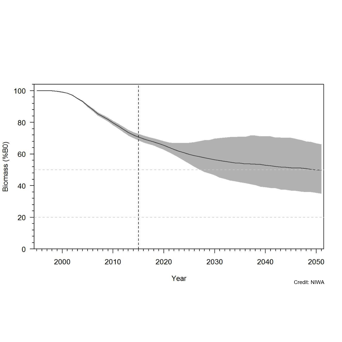
Knowledge of recruitment dynamics, and in particular trends in recruitment and recruitment variability, are key inputs for integrated assessments of fish stocks. A quantitative longline survey monitoring the recruitment of Antarctic toothfish (Dissotichus mawsoni) in the southern Ross Sea was started in 2012. The survey was expanded in 2016 to monitor trends and biological characteristics in two areas of importance to predators, Terra Nova Bay and McMurdo Sound, and to collect data that would contribute to the research and monitoring plan for the Ross Sea region Marine Protected Area. In most years, the survey was completed as planned, while in three years several factors have constrained the survey from sampling all stations and in the latest two seasons pandemic travel restrictions have necessitated an alternative delivery approach. Between 2012 and 2022, 2 056 tagged Antarctic toothfish have been released on the survey and 21 toothfish have been recaptured. Fifteen pop-up satellite archival tags (PSATs) were deployed on D. mawsoni in 2019 and fifteen skates were tagged in 2020 and 2021. Many tagged toothfish released from the RSSS move from the shelf to the slope. Trends in abundance indices and size and age composition consistently show the progression of strong year classes entering and leaving the survey area and have indicated that recruitment is likely more variable than previously thought. Data from the RSSS have been used to indicate year class strength in Antarctic toothfish stock assessments since 2015. The twelve surveys to date have resulted in a substantive increase in the knowledge and understanding of the distribution and relative abundance of a range of demersal fish species and invertebrate taxa caught on the longlines. Other data routinely collected on the surveys were plankton, temperature, salinity, air quality, cetacean and other marine mammal observations, and photo, video, and echosounder data. The RSSS has provided synergies with other research programmes also addressing CCAMLR objectives, particularly those focused on research and monitoring within the RSrMPA. GET DATA: https://www.ccamlr.org/en/publications/statistical-bulletin
-
As part of the Scott Base Redevelopment Marine Monitoring Programme, the impact of Scott Base's activities on the local marine environment was assessed. Sampling took place at three sites around Hut Point Peninsula on the southern half of Ross Island during October – November 2019 to assess anthropogenic contamination. Two acoustic doppler current profilers (ADCP; Nortek Signature 500) were deployed, and set with a 2-minute sampling period in 1m vertical depth bins from the seabed to the underside of the ice. Instrument heads were kept ~0.5 m beneath the under-surface. ADCP data were downloaded, extracted from their raw formats, and averaged into 10-minute intervals. A magnetic declination of 141.09° E was applied to the measured current direction to correct the readings to reflect true north and a pressure offset was applied to standardise depths relative to ambient air pressure at the seawater surface. Information on habitats and benthic epifauna assemblage composition were collected using high resolution video across 2 25m transects at ~22m depth. Multiple overlapping passes were made across the seabed transects at ~0.5 m depth contours between ~20 – 26 m in order to create a 2D orthomosaic image of each site. Analysis of the diver-collected video was done using individual frames. The video along each transect was divided into 10 equal time segments and still frames were taken at random from the first, third, fifth, seventh and ninth segments. Eight video frames were analysed per transect (i.e., n=8 per transect and n=16 per site) by one individual to minimise observer bias. Sediment samples were collected by divers to determine contaminant concentrations and sediment characteristics (sediment particle size composition, organic matter content, organic carbon content and algal pigment content) at each site. Sponge species (Sphaerotylus antarcticus and Laternula elliptica) were collected for tissue contaminant analysis. Full description of methods is available at: https://doi.org/10.1007/s00300-023-03181-1 GET DATA: drew.lohrer@niwa.co.nz
-
The New Zealand Terrestrial Antarctic Biocomplexity Survey (nzTABS) is the largest and most comprehensive interdisciplinary landscape-scale study of terrestrial biology ever undertaken in Antarctica, incorporating fieldwork of 1500+ person days in 6 of the Dry Valleys (total area of 6500 km2), strategic sampling of over 1200 sites designed to encompass the landscape heterogeneities in the ecosystem, and a range of high-resolution remote sensing data. All samples were collected during the month of January in each sampling year. Initially a 220 km2 study area, consisting of Miers, Marshall, and Garwood Valleys as well as Shangri-La, was divided into more than 600 geographically and geologically distinct ice-free sectors (hereinafter “tiles”) using remote-sensing data and published soil maps. Tile boundaries were delineated where the combination of geographical and geological variables changed, and on-the-ground assessments were carried out in November 2008 to confirm the reliability of delineations. 554 tiles were chosen for sampling to encompass the entire range of geographical and geological heterogeneity. Sampling of soils and biological communities was carried out over two successive austral summers (January 2009 and January 2010). Surveys were conducted for vegetation (i.e., mosses, lichens, algal and cyanobacterial mats), lithic microbial communities, and invertebrates at each sampling site (verified by GPS to be inside its respective tile), followed by collection of bulk soil samples for additional analyses, including molecular analyses of bacteria (total and cyanobacteria-only) and fungi. In addition, a number of key variables were derived from satellite imagery, including surface soil temperature, a topographically derived ‘wetness index’, and distance to the coast. After quality control, data for 490 samples were included in the analysis. These data represent geochemistry and geomorphology to population genetics and microbial ecology parameters. Further details are provided at https://doi.org/10.1038/s42003-018-0274-5. Please cite the data with the following citation: Lee, C.K., Laughlin, D.C., Bottos, E.M. et al. Biotic interactions are an unexpected yet critical control on the complexity of an abiotically driven polar ecosystem. Commun Biol 2, 62 (2019). https://doi.org/10.1038/s42003-018-0274-5