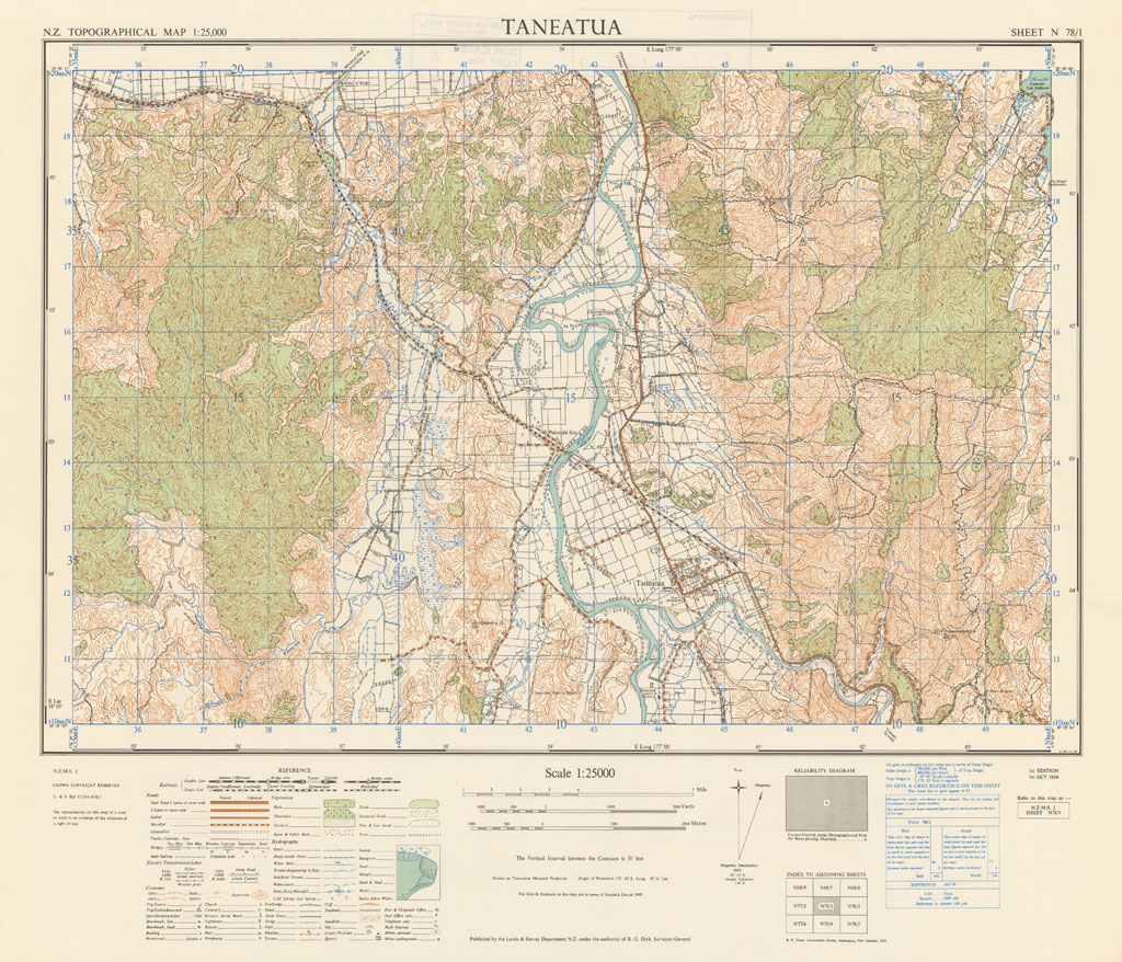
Taneatua
The NZMS 2 series provides topographical information for the New Zealand mainland at the 1:25,000 scale. Only partial coverage of the country was achieved. The series was published from 1942 until its discontinuation in 1972.
Simple
- Citation identifier
- UoA: 99224884414002091
- Date (Publication)
- 1956-10-01T00:00:00
- Edition
-
Edition 1
- Presentation form
- Digital map
- Name
-
NZMS 2
- Issue identification
-
Sheet N78/1
- Other citation details
-
NZMS2, New Zealand Mapping Service
- Collective title
-
New Zealand Topographical Map 1:25,000
- Cited responsible party
-
Organisation name Individual name Electronic mail address Role Department of Lands and Survey
Publisher
- Point of contact
-
Organisation name Individual name Electronic mail address Role Land Information New Zealand
Point of contact
- Maintenance and update frequency
- Not planned
- Keywords
-
-
contours
-
hydrography
-
power lines
-
railways
-
roads
-
settlements
-
vegetation
-
- Other constraints
-
Crown Copyright Reserved
- Other constraints
-
Creative Commons Attribution 4.0 International (CC BY 4.0) Licence ( https://creativecommons.org/licenses/by/4.0/ ).
- Denominator
- 25000
- Topic category
-
- Language
-
eng
- Character set
- UTF8
- Begin date
- 1956-10-01T00:00:00Z
- End date
- 1956-10-01T00:00:00Z
))
- Reference system identifier
- EPSG: 4272 / Datum: New Zealand Geodetic Datum 1949 (NZGD1949)
- Reference system identifier
- EPSG: 27291 / Projection: North Island Yard Grid (NIYG)
- OnLine resource
-
Protocol Linkage Name WWW:LINK-1.0-http--link
https://geodatahub.library.auckland.ac.nz/public/maps/LINZ/NZMS/NZMS_002/jpg/NZMS002_N78-1_1956.jpg 300 ppi JPEG image
- OnLine resource
-
Protocol Linkage Name WWW:LINK-1.0-http--link
https://geodatahub.library.auckland.ac.nz/public/maps/LINZ/NZMS/NZMS_002/tif/NZMS002_N78-1_1956.tif 300 ppi TIFF image
- OnLine resource
-
Protocol Linkage Name WWW:LINK-1.0-http--link
https://geodatahub.library.auckland.ac.nz/public/maps/LINZ/NZMS/NZMS_002/geotif/NZMS002_N78-1_1956_geo.tif 300 ppi GeoTIFF image
- Statement
-
This map was digitised in 2010 by the University of Auckland. The original hardcopy was scanned from the LINZ/NZDF collection held at the NZDF Map Library.
Metadata
- File identifier
- c2858718-1bf0-4675-b888-75733bbe7d54 XML
- Metadata language
- English
- Character set
- UTF8
- Hierarchy level
- Map
- Metadata standard name
-
Based on ISO 19115-1:2014, Geographic Information - Metadata
- Metadata standard version
-
1
- Metadata author
-
Organisation name Individual name Electronic mail address Role The University of Auckland
Point of contact
