 GeoData.NZ
geoscientificInformation
Type of resources
Available actions
Topics
Keywords
Contact for the resource
Provided by
Years
Formats
Representation types
Update frequencies
status
Scale
Resolution
-
This dataset provides information about the position, height, height datum, height accuracy, mark name, mark type, condition and unique four letter identifier for geodetic marks that have an authoritative height in terms of a vertical datum. Heights are in datums defined at http://www.linz.govt.nz/geodetic/datums-projections-heights/vertical-datums/. All marks will have positions in terms a 3D New Zealand official geodetic datum. The horizontal positions of marks are provided for approximate location purposes only . This dataset only contains marks that are within the New Zealand mainland and offshore islands. The height data for these marks have been generated using precise levelling from datum tide gauges, or has been acquired by 3rd party sources either as levelling observations or direct heights. The source data is from Land Information New Zealand's (LINZ) Landonline system where it is used by Land Surveyors. This dataset is updated daily to reflect changes made in the Landonline. Accuracy ============ The accuracy of normal-orthometric heights are described by height orders. For more information see http://www.linz.govt.nz/geodetic/datums-projections-heights/heights/height-orders/. Note the accuracy applies at the time the mark was last surveyed - see the geodetic database for historical information about height coordinates.
-
This data publication contains biostratigraphic age events for the CIROS-1 drill core, updated age ranges for a suite of samples from the McMurdo erratics sample collection, age-depth tie points for CIROS-1, CRP-2/2A, DSDP 270, DSDP 274, ANDRILL 2A and ANDRILL 1B, and glycerol dialkyl glycerol tetraethers (GDGTs) abundances and indices for samples from the McMurdo erratics, CIROS-1, CRP-2/2A, DSDP 270, DSDP 274, ANDRILL 2A, and ANDRILL 1B. All sample sites are in the Ross Sea region of Antarctica. The McMurdo erratics are glacial erratics collected in the McMurdo Sound region between 1991 and 1996 (Harwood and Levy, 2000). The CIROS-1 drill core was collected from McMurdo sound in 1986 with samples spanning the upper Eocene to lower Miocene. CRP-2/2A drill core was collected in 1999 from offshore Victoria Land with samples for this study from the upper Oligocene-lower Miocene. DSDP Site 270 was recovered from the Eastern Basin of the central Ross Sea in 1973, with samples spanning the upper Oligocene-lower Miocene. DSDP Site 274 was drilled on the lower continental rise in the northwestern Ross Sea in 1973, and samples for this study have been taken from the middle Miocene sections of the drill core. The ANDRILL-2A core was recovered in 2007 from Southern McMurdo Sound, samples span the lower Miocene to middle Miocene and data was originally published in Levy et al. (2016). The ANDRILL-IB core was drilled from the McMurdo Ice Shelf in 2006, samples are compiled from the Plio-Pleistocene section of the core and were originally published in McKay et al. (2012). Biostratigraphic age events are described for CIROS-1, expanding on and updating previously published age models and biostratigraphic ranges. Ages are also revised for the McMurdo erratics by updating the ages of the biostratigraphic markers described by (Harwood and Levy (2000) to more recently published age ranges. Age models for the sample sites are developed using published age datums and the Bayesian age-depth modelling functionality in the R package Bchron (Haslett and Parnell, 2008) to ensure a consistent approach for assigning ages to core depths between datums. GDGT abundances and indices for Ross Sea sites are presented to reconstruct ocean temperatures over the Cenozoic era. Detailed methodology for the processing and analysis of samples for GDGTs is described in the methods section of supplement paper.
-
The New Zealand Quasigeoid2009 (NZGeoid2009) can be used to convert GPS derived ellipsoidal heights to New Zealand Vertical Datum 2009 (NZVD2009) normal-orthometric heights that relate more closely to mean sea level and the local gravity field. NZGeoid2009 can also be used to transform heights to any of the 13 official local vertical datums used across New Zealand, more information on this transformation is available at http://www.linz.govt.nz/geodetic/conversion-coordinates/height-conversions. NZGeoid2009 is formally defined in the LINZ standard LINZS25004 which can be obtained from http://www.linz.govt.nz/geodetic/standards-publications/standards. NZGeoid2009 models the difference between the GRS80 ellipsoid and the geoid over the New Zealand region. The geoid is a theoretical surface of equal gravity that roughly approximates the mean level of the sea across the Earth. NZGeoid2009 is published by LINZ and was computed by enhancing the EGM2008 global gravity model with terrestrial gravity observations over New Zealand and DNSC08 satellite altimetry data over the oceans. The model is published on a one arc-minute grid covering New Zealand's extended exclusive economic zone. The accuracy of NZGeoid2009 is nominally ±0.08 metres across New Zealand. More information on the accuracy in relation to the 13 local vertical datums is provided in LINZS25004.
-
The NZGD2000 Government CORS provides the locations of GNSS Continuously Operating Reference Stations operated by GNS Science under the GeoNet project (http://www.geonet.org.nz). Coordinates are from the LINZ Geodetic Database, in NZGD2000. These are split into several different networks: - PositioNZ - stations predominantly funded by LINZ, with some GeoNet funding. These provide a nationwide coverage of ~120km spacing. More info [here](http://apps.linz.govt.nz/positionz/) - GeoNet - stations funded by the GeoNet project. These are located in areas of geophysical interest, usually on the East Coast of the North Island. More info [here](http://www.geonet.org.nz) - SAGENZ - stations funded by the University of Otago, GNS Science, MIT, University of Colorado and UNAVCO. These Southern Alps Geodetic Experiment - New Zealand stations are generally semi-continuous sites. - Tide Gauge - stations co-located with tide gauges at major ports. Data is managed through the GeoNet project also. 30" RINEX data from all of these sites is available from the [GeoNet website](http://www.geonet.org.nz) Real Time data is available from all PositioNZ stations, and some GeoNet stations. For more information, see the [PositioNZ-RT website](http://apps.linz.govt.nz/positionz/rt/index.php)
-
The New Zealand Quasigeoid2009 (NZGeoid2009) can be used to convert GPS derived ellipsoidal heights to New Zealand Vertical Datum 2009 (NZVD2009) normal-orthometric heights that relate more closely to mean sea level and the local gravity field. NZGeoid2009 can also be used to transform heights to any of the 13 official local vertical datums used across New Zealand, more information on this transformation is available at http://www.linz.govt.nz/geodetic/conversion-coordinates/height-conversions. NZGeoid2009 is formally defined in the LINZ standard LINZS25004 which can be obtained from http://www.linz.govt.nz/geodetic/standards-publications/standards. NZGeoid2009 models the difference between the GRS80 ellipsoid and the geoid over the New Zealand region. The geoid is a theoretical surface of equal gravity that roughly approximates the mean level of the sea across the Earth. NZGeoid2009 is published by LINZ and was computed by enhancing the EGM2008 global gravity model with terrestrial gravity observations over New Zealand and DNSC08 satellite altimetry data over the oceans. The model is published on a one arc-minute grid covering New Zealand's extended exclusive economic zone. The accuracy of NZGeoid2009 is nominally ±0.08 metres across New Zealand. More information on the accuracy in relation to the 13 local vertical datums is provided in LINZS25004.
-
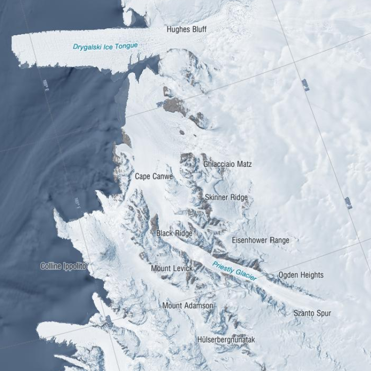
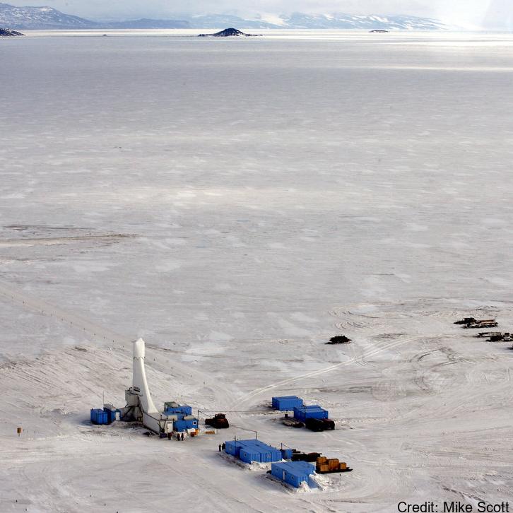
These data were aquired with a Terrestrial Radar Interferometer overlooking the grounding zone of Priestley Glacier, Antarctica. The time series contains differential interferograms with a 12h temporal baseline covering an approximately 8 day period in November 2018. Tidal modulation of ice streams and their adjacent ice shelves is a real-world experiment to understand ice-dynamic processes. We observe the dynamics of Priestley Glacier, Antarctica, using Terrestrial Radar Interferometry (TRI) and GNSS. Ocean tides are predominantly diurnal but horizontal GNSS displacements oscillate also semi-diurnally. The oscillations are strongest in the ice shelf and tidal signatures decay near-linearly in the TRI data over >10 km upstream of the grounding line. Tidal flexing is observed >6 km upstream of the grounding line including cm-scale uplift. Tidal grounding line migration is small and <40 % of the ice thickness. The frequency doubling of horizontal displacements relative to the ocean tides is consistent with variable ice-shelf buttressing demonstrated with a visco-elastic Maxwell model. Taken together, this supports previously hypothesized flexural ice softening in the grounding-zone through tides and offers new observational constraints for the role of ice rheology in ice-shelf buttressing. Related Publication: Drews, R., Wild, C. T., Marsh, O. J., Rack, W., Ehlers, T. A., Neckel, N., & Helm, V. (2021). Grounding-zone flow variability of Priestley Glacier, Antarctica, in a diurnal tidal regime. Geophysical Research Letters, 48, e2021GL093853. https://doi.org/10.1029/2021GL093853 GET DATA: https://doi.org/10.1594/PANGAEA.935707
-
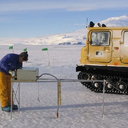
Data provided here have been collected as part of the project "Measurements and Improved Parameterization of the Thermal Conductivity and Heat Flow through First-Year Sea Ice", OPP-0126007* and include measurements of temperature and various ice properties at selected sites in first-year and multiyear sea ice in McMurdo Sound, Antarctica in the years 2002-2004. Data from earlier installations of thermistor chains for measurements of ice temperature carried out by the New Zealand team have also been included. Data files are in Microsoft Excel format, with individual worksheets for specific cores or temperature data sets. Detailed information and comments on data sampling location etc. are provided in the files. Further information on data collection, results etc. can be found in the following publications: Backstrom, L. G. E., and H. Eicken 2007, submitted, Capacitance probe measurements of brine volume and bulk salinity in first-year sea ice, Cold Reg. Sci. Tech. Pringle, D. J., H. Eicken, H. J. Trodahl, and L. G. E. Backstrom 2007, submitted, Thermal conductivity of landfast Antarctic and Arctic sea ice, J. Geophys. Res. Trodahl, H. J., S. O. F. Wilkinson, M. J. McGuinness, and T. G. Haskell 2001, Thermal conductivity of sea ice; dependence on temperature and depth, Geophys. Res. Lett., 28, 1279-1282. Data are in Microsoft Excel format. Abbreviations: AH = Arrival Heights; CH = Camp Haskell (near Delbridge Islands); VUW = Victoria University Wellington; UAF = University Alaska Fairbanks. RELATED PUBLICATION: https://doi.org/10.1017/jog.2022.108 GET DATA: https://drive.google.com/drive/folders/1ooUH9dPvWT66afFC51Cb0JOHg66rn0sy
-
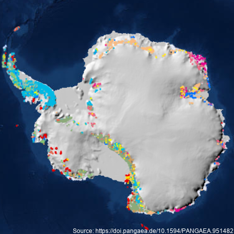
A dataset describing exposed bedrock and surficial geology of Antarctica constructed by the GeoMAP Action Group of SCAR (The Scientific Committee on Antarctic Research) and GNS Science, New Zealand. Legacy geological map data have been captured into a geographic information system (GIS), refining its spatial reliability, harmonising classification, then improving representation of glacial sequences and geomorphology. A total 99,080 polygons have been unified for depicting geology at 1:250,000 scale, but locally there are some areas with higher spatial precision. Geological definition in GeoMAP v.2022-08 is founded on a mixed chronostratigraphic- and lithostratigraphic-based classification. Description of rock and moraine polygons employs international GeoSciML data protocols to provide attribute-rich and queriable data; including bibliographic links to 589 source maps and scientific literature. Data are provided under CC-BY License as zipped ArcGIS geodatabase, QGIS geopackage or GoogleEarth kmz files. GeoMAP is the first detailed geological dataset covering all of Antarctica. GeoMAP depicts 'known geology' of rock exposures rather than 'interpreted' sub-ice features and is suitable for continent-wide perspectives and cross-discipline interrogation. Further details are provided at: Cox, S.C., Smith Lyttle, B., Elkind, S. et al. A continent-wide detailed geological map dataset of Antarctica. Sci Data 10, 250 (2023). https://doi.org/10.1038/s41597-023-02152-9 GET DATA: https://doi.pangaea.de/10.1594/PANGAEA.951482
-
These data are described in detail by 'Melting and refreezing in an ice shelf basal channel at the grounding line of the Kamb Ice Stream. ApRES observations were made in December 2019 and repeated in December 2020 at the same locations. Data collection and processing followed the method described in Stewart et al. (2019). ApRES dataset.zip' contains raw ApRES data and processed results from a spatial survey of basal mass balance - detailed in Sections 2.2.4 and 3.2.2 of: Whiteford, A., Horgan, H. J., Leong, W. J., & Forbes, M. (2022). Melting and refreezing in an ice shelf basal channel at the grounding line of the Kamb Ice Stream, West Antarctica. Journal of Geophysical Research: Earth Surface, 127, e2021JF006532. https://doi.org/10.1029/2021JF006532 GET DATA: https://doi.org/10.5281/zenodo.5574647
-
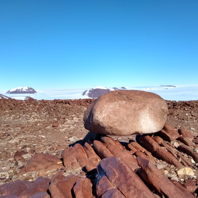
Cosmogenic surface exposure chronologies were used to quantitatively constrain past rates of ice thinning, and the absolute timing of ice discharge and thinning events. We sampled glacial erratics and bedrock from Byrd Glacier (LW1 Nunatak, LW2 Nunatak, Lonewolf Nuntataks, Tiger Nunatak, Mt. Tadpole). Samples were analysed for their exposure history, and all sites contained glacial erratics. In particular, the Lonewolf Nunataks sites, which is located along the margin of the East Antarctic Ice Sheet revealed a plethora of glacial cobbles. Details of laboratory procedures can be found in the related publication. RELATED PUBLICATION: https://doi.org/10.1002/esp.5701 GET DATA: https://version2.ice-d.org/antarctica/publication/1139/