 GeoData.NZ
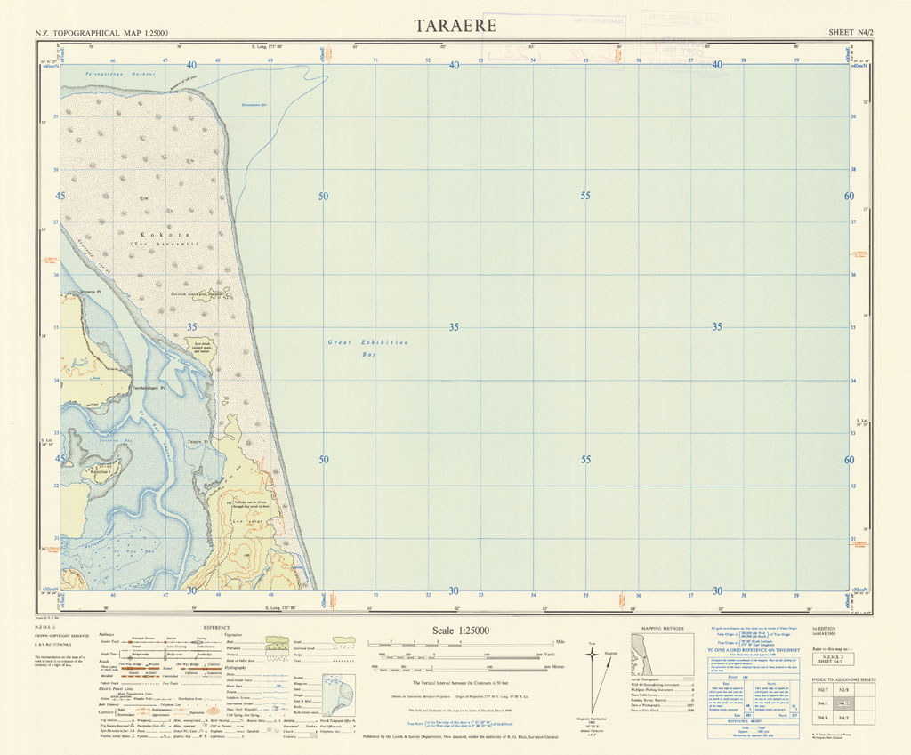
Taraere
The NZMS 2 series provides topographical information for the New Zealand mainland at the 1:25,000 scale. Only partial coverage of the country was achieved. The series was published from 1942 until its discontinuation in 1972.
Simple
- Identifier
- UoA: 99224889114002091
- Date (Publication)
- 1960-03-01T00:00:00
- Edition
- Edition 1
- Presentation form
- Digital map
- Name
- NZMS 2
- Issue identification
- Sheet N4/2
- Other citation details
- NZMS2, New Zealand Mapping Service
- Collective title
- New Zealand Topographical Map 1:25,000
Point of contact
Land Information New Zealand
0800 665 463 (toll free within NZ)
+ 64 4 472 2244
https://www.linz.govt.nz/
PO Box 5501
,
Wellington
,
6145
,
New Zealand
+ 64 4 460 0110
0800 665 463 (toll free within NZ)
+ 64 4 472 2244
https://www.linz.govt.nz/
- Maintenance and update frequency
- Not planned
- Keywords
-
- contours
- hydrography
- power lines
- railways
- roads
- settlements
- vegetation
- Other constraints
- Crown Copyright Reserved
- Other constraints
- Creative Commons Attribution 4.0 International (CC BY 4.0) Licence (https://creativecommons.org/licenses/by/4.0/).
- Denominator
- 25000
- Topic category
-
- Metadata language
- eng
- Character set
- UTF8
- Begin date
- 1960-03-01T00:00:00Z
- End date
- 1960-03-01T00:00:00Z
N
S
E
W
))
- Reference system identifier
- EPSG: 4272 / Datum: New Zealand Geodetic Datum 1949 (NZGD1949)
- Reference system identifier
- EPSG: 27291 / Projection: North Island Yard Grid (NIYG)
- OnLine resource
- 300 ppi JPEG image ( WWW:LINK-1.0-http--link )
- OnLine resource
- 300 ppi TIFF image ( WWW:LINK-1.0-http--link )
- OnLine resource
- 300 ppi GeoTIFF image ( WWW:LINK-1.0-http--link )
- Statement
- This map was digitised in 2010 by the University of Auckland. The original hardcopy was scanned from the LINZ/NZDF collection held at the NZDF Map Library.
- File identifier
- da063418-b5d5-4a19-a015-6f53de147573 XML
- Metadata language
- English
- Character set
- UTF8
- Hierarchy level
- Map
- Metadata standard name
- Based on ISO 19115-1:2014, Geographic Information - Metadata
- Metadata standard version
- 1
Point of contact
The University of Auckland
-
GeoDataHub Manager
Private Bag 92019
,
Auckland
,
1142
,
New Zealand
https://geodatahub.library.auckland.ac.nz/
Overviews
Preview
Spatial extent
N
S
E
W
Provided by

Associated resources
Not available