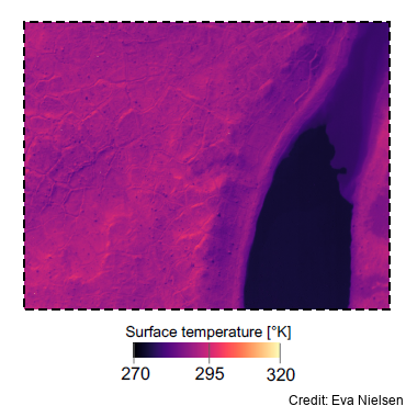
Aerial Infrared Imagery of Surface Energy Flux at Terra Nova Bay, Commonwealth Glacier, Taylor Valley, and McMurdo Dry Valleys, 2022-2023
This metadata records represents aerial surveying of land temperature variability and microclimate, with an infrared and visible camera system. In December and January 2023, airborne surveys were undertaken in the Taylor Valley in the McMurdo Dry Valleys, plus one scan along the coastline to Terra Nova Bay. Pre-defined flight tracks covered three different areas, chosen for their different surfaces and moisture content. The flights were timed to coincide with MODIS and Landsat satellite overpasses
The data was used to: (1) validate a newly developed geostatistical downscaling model for land surface temperature in the unique environment of the McMurdo Dry Valleys; (2) investigate bias in satellite derived land and ice surface temperature related to subpixel variations in surface types; (3) validate WRF-Hydro/Glacier model performance in simulating spatially distributed conditions for melt and the routing of meltwater; (4) lay some of the groundwork for establishing a network of ecological “sentinel sites”, where the greatest environmental change is expected.
Data is in HCC format for the infrared and JPG for RGB imagery.
GET DATA: eva.nielsen@pg.canterbury.ac.nz or marwan.katurji@canterbury.ac.nz
Simple
- Date (Creation)
- 2024-05-31T09:48:46
- Date (Publication)
- 2024-05-31T09:48:47
Citation identifier
Citation identifier
- Status
- On going
- Point of contact
-
Organisation name Individual name Electronic mail address Role Katurji, M.
Author Bendix Nielsen, E.
coAuthor University of Canterbury
Publisher
- Maintenance and update frequency
- As needed
- Keywords
-
-
TAYLOR VALLEY
-
COMMONWEALTH GLACIER
-
MCMURDO DRY VALLEYS
-
K881B
-
- GCMD Earth Science and Earth Science Services Keywords
-
-
GLACIERS
-
CRYOSPHERIC INDICATORS
-
MICROCLIMATE
-
SURFACE TEMPERATURE
-
GLACIER MELT
-
THERMAL INFRARED
-
- GCMD Platform/Sources Keywords
-
-
HELICOPTER
-
Data Collections
-
- GCMD Instrument Keywords
-
-
MODIS
-
INFRARED RADIOMETERS
-
- GCMD Locations Keywords
-
-
TERRA NOVA BAY
-
ANTARCTICA
-
- Use limitation
-
This data set conforms to the CC BY Attribution License ( https://creativecommons.org/licenses/by/4.0/ )
- Hierarchy level
- Dataset
- Date
- Statement
-
Creative Commons Attribution 4
- gmd:disseminationConstraints
- License
- Access constraints
- License
- Use constraints
- License
- Aggregate Datasetindentifier
- 5a446d46-7f97-41dd-9f1c-fdb8dd1e706a
- Association Type
- Cross reference
- Initiative Type
- Project
- Language
- English
- Character set
- UTF8
- Topic category
-
- Climatology, meteorology, atmosphere
))
- Begin date
- 2022-12-17T00:00:00
- End date
- 2023-01-07T00:00:00
- Distribution format
-
Name Version
- OnLine resource
-
Protocol Linkage Name WWW:LINK-1.0-http--link
https://antcat.antarcticanz.govt.nz:/geonetwork/srv/api/records/ac86832e-ca3c-4102-815b-fa0d351da773/attachments/aerial_infrared_imagery.kml McMurdo Dry Valleys Locations (KML)
Metadata
- File identifier
- ac86832e-ca3c-4102-815b-fa0d351da773 XML
- Metadata language
- English
- Character set
- anyValidURI
- Hierarchy level
- Dataset
- Date stamp
- 2024-07-16T05:45:43.653Z
- Metadata standard name
-
ISO 19115
- Metadata standard version
-
2003
- Metadata author
-
Organisation name Individual name Electronic mail address Role University of Canterbury
Point of contact

