ApRES Measurements at North-Western Ross Ice Shelf, 2021-Present
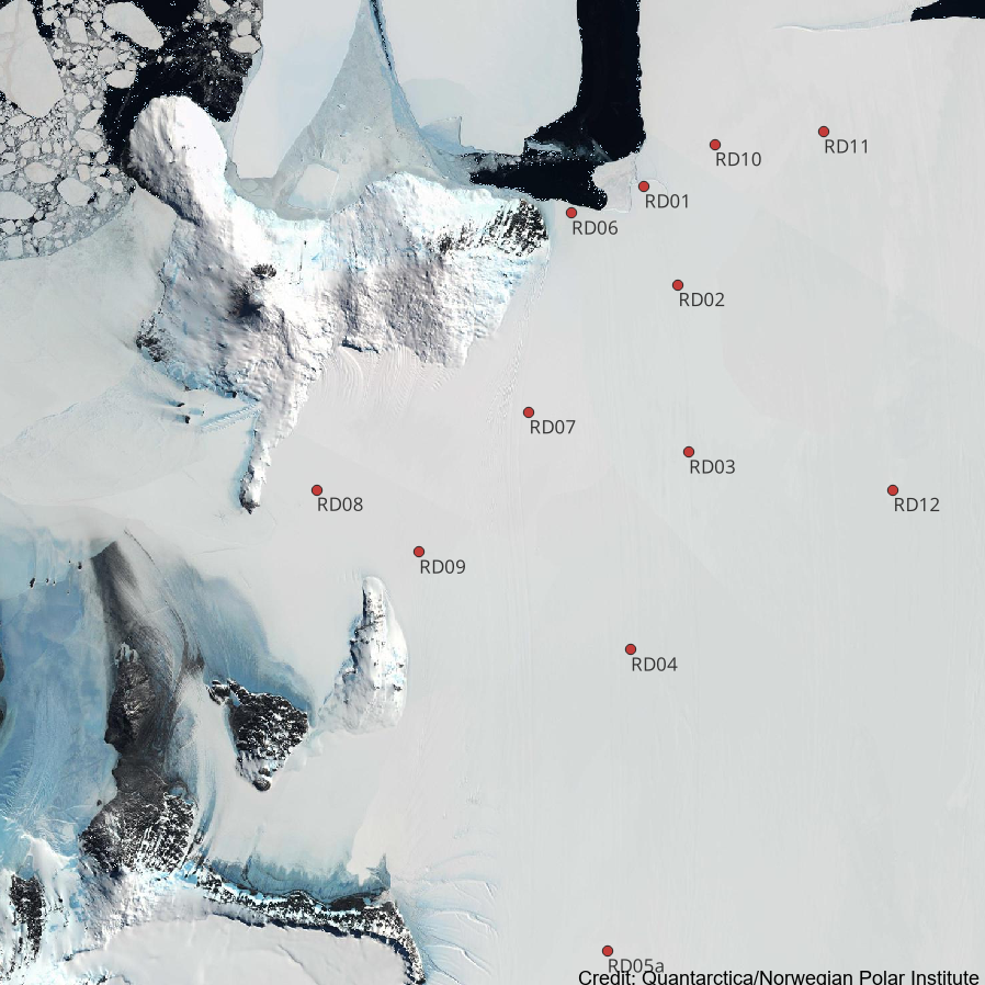
12 ApRES (Autonomous phase-sensitive Radio Echo Sounder) ice-penetrating radars were deployed on the Ross Ice Shelf in 2021/22 to measure basal melting. Each radar measures a profile of the ice shelf, typically at hourly intervals. Changes in the range of the basal and internal reflectors can be used to estimate basal melting. Instruments return a small subset of data in near real time via Iridium SBD telemetry, allowing a crude estimate of melting. Full resolution data is stored the instrument and can only be recovered with site visits. Instruments suffered failures during 2022, so the data sets have significant gaps within 2022/23.
Data type: Binary as described in ApRES manual
Instrument details are provided at:
Nicholls KW, Corr HFJ, Stewart CL, Lok LB, Brennan PV, Vaughan DG. A ground-based radar for measuring vertical strain rates and time-varying basal melt rates in ice sheets and shelves. Journal of Glaciology. 2015;61(230):1079-1087. https://doi.org/10.3189/2015JoG15J07 3
GET DATA: craig.stewart@niwa.co.nz
Simple
- Date (Creation)
- 2024-05-31T13:43:42
- Date (Publication)
- 2024-05-31T13:43:43
Citation identifier
- Point of contact
-
Organisation name Individual name Electronic mail address Role Stewart, C.
Author National Institute of Water and Atmospheric Research (NIWA)
Publisher
- Maintenance and update frequency
- As needed
- Keywords
-
-
APRES
-
BASAL MELT RATE
-
ROSS ICE SHELF
-
INSTALLATION
-
K872B
-
- GCMD Earth Science and Earth Science Services Keywords
-
-
ICE SHELVES
-
CRYOSPHERIC INDICATORS
-
- GCMD Platform/Sources Keywords
-
-
Ice Shelf
-
Data Collections
-
- GCMD Locations Keywords
-
-
ANTARCTICA
-
- Use limitation
-
This data set conforms to the CC BY Attribution License ( https://creativecommons.org/licenses/by/4.0/ )
- Hierarchy level
- Dataset
- Date
- Statement
-
Creative Commons Attribution 4
- gmd:disseminationConstraints
- License
- Access constraints
- License
- Use constraints
- License
- Language
- English
- Character set
- UTF8
- Topic category
-
- Geoscientific information
Extent
))


- Begin date
- 2021-12-01T00:00:00
- Distribution format
-
Name Version
- OnLine resource
-
Protocol Linkage Name WWW:LINK-1.0-http--link
https://antcat.antarcticanz.govt.nz:/geonetwork/srv/api/records/40b1e023-5109-4946-a452-6a1fd5143351/attachments/40b1e023-5109-4946-a452-6a1fd5143351.csv Instrument Locations and Deployment Dates
Metadata
- File identifier
- 40b1e023-5109-4946-a452-6a1fd5143351 XML
- Metadata language
- English
- Character set
- anyValidURI
- Hierarchy level
- Dataset
- Date stamp
- 2024-07-16T05:40:30.924Z
- Metadata standard name
-
ISO 19115
- Metadata standard version
-
2003
- Metadata author
-
Organisation name Individual name Electronic mail address Role National Institute of Water and Atmospheric Research (NIWA)
Point of contact