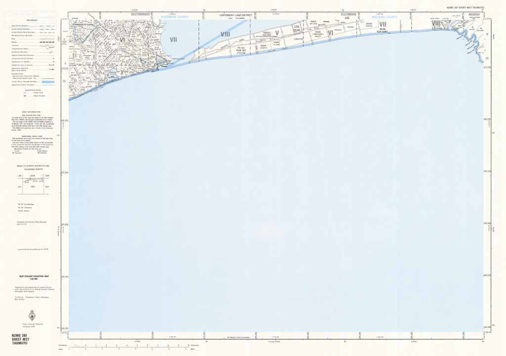
Taumutu
The NZMS 261 series provides cadastral information for the New Zealand mainland and Chatham Islands at the 1:50,000 scale. Full coverage of the country was achieved except Three Kings Islands and Fiordland, which were intentionally omitted. The series was published between 1974 and 1991. It was replaced by the Landonline service.
Simple
- Citation identifier
- UoA: 261000000273tmp
- Date (Publication)
- 1976-01-01T00:00:00
- Edition
-
Edition 1
- Presentation form
- Digital map
- Name
-
NZMS 261
- Issue identification
-
Sheet M37
- Other citation details
-
NZMS261, New Zealand Mapping Service
- Collective title
-
New Zealand Cadastral Map 1:50,000
- Cited responsible party
-
Organisation name Individual name Electronic mail address Role Department of Lands and Survey
Publisher
- Point of contact
-
Organisation name Individual name Electronic mail address Role Land Information New Zealand
Point of contact
- Maintenance and update frequency
- Not planned
- Keywords
-
-
administrative boundaries
-
deposited plan (DP) boundaries
-
Maori blocks
-
subdivision boundaries
-
railways
-
roads
-
survey districts
-
trigonometrical stations
-
- Other constraints
-
Crown Copyright Reserved
- Other constraints
-
Creative Commons Attribution 4.0 International (CC BY 4.0) Licence ( https://creativecommons.org/licenses/by/4.0/ ).
- Denominator
- 50000
- Topic category
-
- Language
-
eng
- Character set
- UTF8
- Begin date
- 1976-01-01T00:00:00Z
- End date
- 1976-01-01T00:00:00Z
))
- Reference system identifier
- EPSG: 4272 / Datum: New Zealand Geodetic Datum 1949 (NZGD1949)
- Reference system identifier
- EPSG: 27200 / Projection: New Zealand Map Grid (NZMG)
- OnLine resource
-
Protocol Linkage Name WWW:LINK-1.0-http--link
https://geodatahub.library.auckland.ac.nz/public/maps/LINZ/NZMS/NZMS_261/jpg/NZMS261_M37_1976.jpg 300 ppi JPEG image
- OnLine resource
-
Protocol Linkage Name WWW:LINK-1.0-http--link
https://geodatahub.library.auckland.ac.nz/public/maps/LINZ/NZMS/NZMS_261/tif/NZMS261_M37_1976.tif 300 ppi TIFF image
- OnLine resource
-
Protocol Linkage Name WWW:LINK-1.0-http--link
https://geodatahub.library.auckland.ac.nz/public/maps/LINZ/NZMS/NZMS_261/geotif/NZMS261_M37_1976_geo.tif 300 ppi GeoTIFF image
- Statement
-
This map was digitised in 2010 by the University of Auckland. The original hardcopy was scanned from the LINZ/NZDF collection held at the NZDF Map Library.
Metadata
- File identifier
- 013a2128-21e7-4d40-b74c-98951b8ab1e4 XML
- Metadata language
- English
- Character set
- UTF8
- Hierarchy level
- Map
- Metadata standard name
-
Based on ISO 19115-1:2014, Geographic Information - Metadata
- Metadata standard version
-
1
- Metadata author
-
Organisation name Individual name Electronic mail address Role The University of Auckland
Point of contact
